Donneville à l'automne - © Alexandre Menard

The Canal du Midi,
the 1st long summit-level canal

Pierre-Paul Riquet took inspiration from the Canal du Briare and drew on his experiments in hydraulics to create the first long summit-level canal. From its route to the engineering structures, the entire Canal du Midi is proof of its creator's ingenuity and the inventive solutions he came up with to supply the canal with water.

A summit-level canal

Definition of a summit-level canal

We speak of a summit-level canal when it crosses over a high watershed point between two basins. The highest section of the canal between two locks, known as the summit pound, must be supplied with water.

The Montagne Noire, where Riquet designed his very own water tower

The first summit-level canal in France was the Canal de Briare, which connected the Loire and the Seine.
It opened to navigation in 1642, and served as inspiration for Pierre-Paul Riquet.

Firstly, Riquet had to ensure the availability of water resources. Thanks to his observations in the Montagne Noire region, in the far south of the Massif Central, and his experiments in the grounds of his Château de Bonrepos, Riquet very quickly came to the conclusion that the Montagne Noire could act as the perfect water tower for his future canal.

It 'simply' required using a channel to deviate the small but many streams and rivers in this mountainous area, to guide the water to the Seuil de Naurouze, the watershed point between the Atlantic and Mediterranean basins.

The water supply system

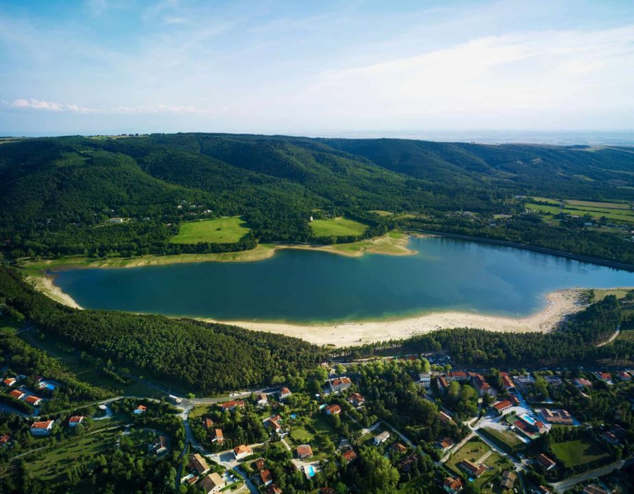
Saint Ferréol, the Canal du Midi's supply of water

But there are 80 kilometres between the Alzeau water inlet and the Seuil de Naurouze! This wouldn't be a problem in winter, but what about in summer when the water flows are significantly weaker?

In the early stages of his project, Riquet had considered creating several water storage locations to ensure supply to the canal.  

In the end, only one of these was actually built, but that didn't matter! Saint Ferréol dam was built between 1667 and 1680, and was for a long time considered to be the biggest dam in Europe.  

On the hunt for
the best route for the Canal du Midi

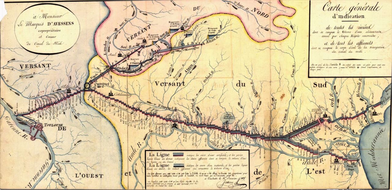
Choosing a route to fit the landscape

To find the best possible route for his canal, Pierre-Paul Riquet called upon the very best levellers and cartographers, including Jean Cavalier and François Andreossy.

The topography of the regions the canal would be passing through was a challenge to overcome. Between the locks, each section (or canal pound) has to be horizontal. To connect two points which are sometimes quite far from one another, the canal route had to follow the contour lines. That is why the route is a winding one.

Nestled in the Lauragais, Minervois valleys and the hilly Biterrois region, the Canal du Midi follows the natural curves of the land, and thanks to the force of gravity, the water flows along a regular but gentle slope. 
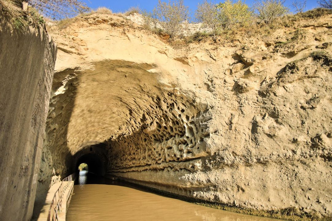
The Mediterranean basin and the issue of crossing rivers

Riquet wanted to limit river crossings in the Mediterranean basin. This is because when water levels are very high, navigation along the Canal du Midi could be severely disrupted or even suspended! He therefore chose to build his canal on the left banks of the Tréboul river, then on the right banks of the Fresquel river, and finally along the left banks of the river Aude.

This decision meant he had to sacrifice the section through Narbonne, despite Royal recommendations to include this passage. From Argens-Minervois, the route then goes directly towards Béziers, leaving the river Aude behind. 

Malpas tunnel,
a daring technical achievement

The connection between Argens and Béziers was created by an incredible 54-kilometre-long canal pound (section without a lock).

To bring this remarkable idea to life, Riquet dug straight into the mountain, and created Malpas tunnel.

There was a lot of doubt surrounding these plans and it almost didn't go ahead, but Riquet's firm convictions and sheer determination triumphed!

The highlight of this 54-km canal pound is the extraordinary Fonserannes locks, with eight consecutive chambers and 23 metres difference in water level.

From Béziers, the canal still needed to reach Thau lagoon to access the port of Sète and the Mediterranean Sea. Taking advantage of the best nature has to offer, the levellers designed a route very close to the coast. They used the water resources of the Orb and Hérault rivers to separate the water supply on the east section of the canal from the rest.

Finally, in Agde, Riquet seized the opportunity to establish a link with the maritime port there, and built a round lock with exits in different directions.

Agde Round Lock

The longest summit-level canal

Riquet and his teams always aimed to make the most of the wonders nature had to offer! That is how they managed to create the link between the Atlantic Ocean and Mediterranean Sea. 

To the 240 navigable kilometres, they added 80 kilometres for the water system and so created the longest and the most beautiful summit-level canal, named the Canal Royal du Languedoc (and would remain so for a long time). The Canal du Midi was very quickly recognised as a wonder of Europe, and is one of the most extraordinary civil engineering achievements of the modern era.

Coupe du canal dénivelé - VNF

Coupe du canal dénivelé - VNF

The Canal du Midi:
a masterpiece with continuous improvements

When Pierre-Paul Riquet died in October 1680, other people took over his masterpiece. Vauban, Niquet, Pin, Saget, Garipuy, Maguès are among the most well-known, whose task was to make improvements to the original project, to make additions and design extensions. 

These successive modifications were all designed with architectural expression and landscape in mind. This continuous, well-thought-out work made the Canal du Midi not only a technical feat, but also a sort of work of art, recognised by UNESCO when the Canal du Midi was added to the list of World Heritage sites in 1996.