The Canal du Midi water supply:
Riquet's ingenious system
Supplying water to a summit-level canal that is as long as the Canal du Midi requires a certain technique and expert knowledge in hydraulics. Thanks to his advanced studies and his many experiments, Pierre-Paul Riquet achieved what his predecessors had not managed to do and came up with ingenious solutions.
The ingenious solution designed by Riquet
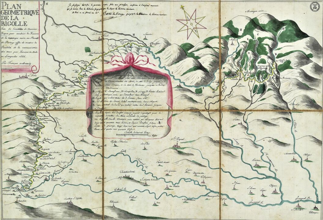
In the 1650s, Pierre-Paul Riquet looked into the advantage of using the smaller rivers of the Montagne Noire region, in the foothills of the Massif Central. Riquet planned on using the waters of the river Sor. He also planned on diverting the rivers from the Mediterranean basin to the Atlantic basin side, using a man-made channel in the Sor valley guiding to the Seuil de Naurouze, the watershed point where waters flow to the Atlantic on one side and the Mediterranean on the other.

The plans for the Canal du Midi water supply system
The Montagne Noire and the waters of the Sor
The project that Riquet presented to Colbert on 15 November 1662 was based on the creation of two sections of a man-made channel:
- The Rigole de la Montagne channel: at 500 metres above sea level, this channel diverts the waters of the Mediterranean basin in the Montagne Noire, from Alzeau to Conquet.
- The Rigole de la Plaine channel: after flowing across the watershed point between the Atlantic and Mediterranean basins, the water ends up in the Sor valley. It is then collected from the Sor, upstream from Revel, and channeled to the watershed point.
To make up for the scarce water resources in summer, Riquet planned on building a dozen small reservoirs. Riquet called them 'magasins d’eau' (water storehouses) or provision basins. In the end, these small basins were replaced by one single, vast reservoir on the Laudot river, a tributary of the Sor, at Saint-Ferréol.
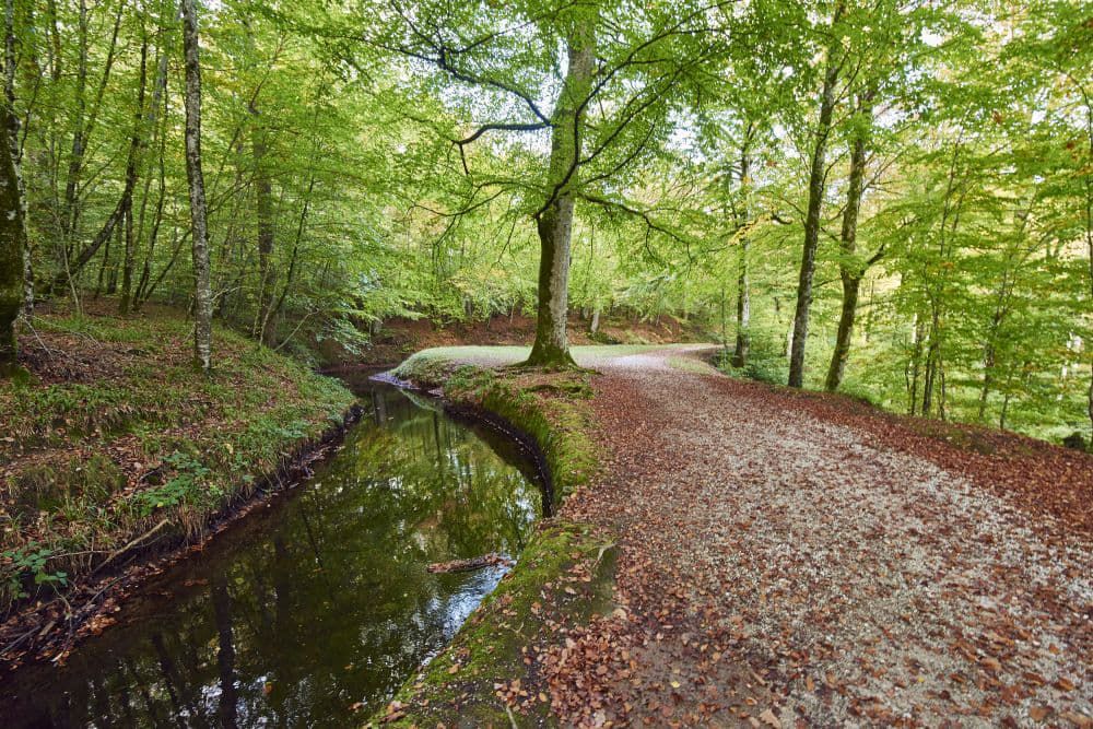
The Rigole de Montagne channel
The Rigole de la Montagne, at an elevation of between 650 and 550 metres, collects the waters from the Mediterranean basin in the Montagne Noire region.
The Rigole de la Montagne originates from the streams on the south side of the mountain, and then flows into a waterway on the north side, the Sor, in the hamlet of Le Conquet, at 'Le Saut du Sor'. Once the Sor has been filled with the waters from this channel, the waters are deviated to the Rigole de la Plaine channel at the town of Sorèze, supplying water to the town of Revel and the Seuil de Naurouze.
In 1689, Vauban improved the canal and the water supply system. He connected the Rigole de la Montagne to Laudot stream via an underground route he called the Voûte Vauban in today's town of Cammazes.
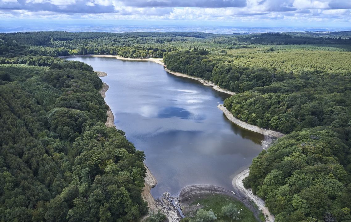
Saint-Ferréol Lake
Saint-Ferréol reservoir is at an elevation of 350 metres and has the capacity for 5,000,000 m3 of water!
This unique reservoir lake is used to supply water to the canal from toulouse to Carcassonne, and completes the supply of the entire canal in periods of drought.
It's also a delight for tourists and locals who enjoy this swimming and leisure area.
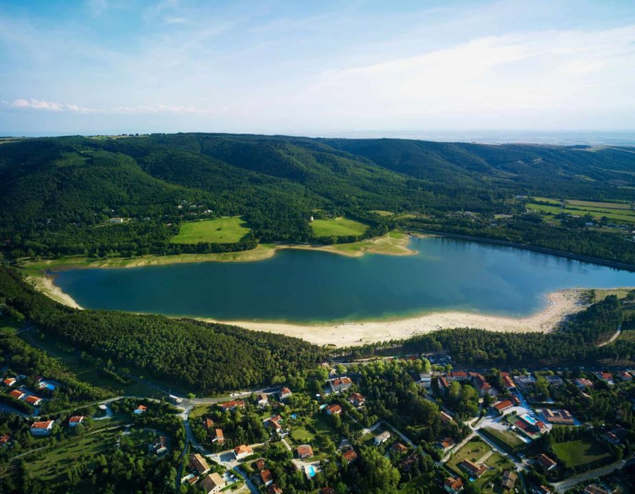
Saint-Ferréol reservoir
Saint-Ferréol reservoir lake gets its water supply from Laudot stream, and is then joined onto the Rigole de la Plaine channel, to supply water if needed at a place called 'Les Thoumazés'.
The Rigole de la Plaine channel
The Rigole de la Plaine (at an elevation of between 245 and 189 metres) is used to carry water to the Seuil de Naurouze, the highest point of the Canal du Midi.
The channel begins at Pont-Crouzet and then collects the waters of the Sor, then the Laudot and channels this water as far as Naurouze. The total length of the Rigole de la Plaine is 38.120 km, and it is approximately 2 metres wide.
At the Seuil de Naurouze, this watershed point, water flows west towards Toulouse, and east towards the Mediterranean.
Water supply scheme of the Montagne Noire today

This system was made all the more complex in 1950 when new reservoirs for the production of drinking water and farming irrigation were built. These reservoirs are connected to the hydraulics network of the Canal du Midi water supply system.
Over 350 years after its creation, Riquet's water supply system is now fully integrated into a vast network of water that now has a wide range of different uses!
Other water supply sources from Carcassonne to Béziers
There are four extra water inlets from rivers, to supply water to the canal from Carcassonne to Béziers (99 km) as well as for the Canal de Jonction (5 km). The capacity of the canal pounds is 3.3 Mm3, for this part of the Canal du Midi and 0.165 Mm3 for the Canal de Jonction.- Lachaux water inlet on the Fresquel in Villemoustoussou, now abandoned.
- Villedubert water inlet on the Aude, in Villedubert
- Orbiel water inlet on the river Orbiel in Trèbes, now abandoned.
- Cesse water inlet on the river Cesse in Mirepeisset

